Most people driving US-2 through the Flathead Valley do not look east. That is their loss.
The Swan Range runs along the western edge of the Bob Marshall Wilderness for roughly 80 miles. To the west lies the Swan Valley and Flathead Lake. To the east, the wilderness. The range tops out between 8,000 and 9,000 feet, and the terrain in between is the kind that earns its views.
The area and what it offers
The Swan Range is not a single destination. It is a long chain of ridges, glacial lakes, and forested valleys that gives hikers a range of starting points depending on what they came for.
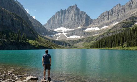
The most-visited section is Jewel Basin Hiking Area, a 15,000-acre pocket in the Flathead National Forest set aside exclusively for hikers and horseback riders, with no motorized vehicles and no bikes. It sits north of the range above Bigfork and holds around 35 lakes, most of them reachable on day trips. The basin takes its name from the concentration of small alpine lakes, each a different shade of green depending on the sky and the season.
The Swan Valley corridor below the range, anchored by towns like Condon and Seeley Lake, gives access to lower-elevation trails along the Swan River and its tributaries. Those valleys hold bull trout and westslope cutthroat in their streams, and the hiking there is gentler than the ridge routes above.
The Bob Marshall Wilderness boundary sits just over the east face of the range. Most visitors day-hike from the Swan Valley side. Wilderness travel on the Bob requires a bit more logistics, but the western trailheads are accessible and well-maintained.
Notable trails and destinations
Jewel Basin is the practical starting point for most Swan Range visitors. The main trailhead at Camp Misery sits at roughly 5,400 feet. From there, trails fan out to most of the basin’s lakes. The upper lakes involve real climbing, around 1,500 to 2,000 feet of gain on the more popular routes, but the terrain is open and the footing is solid once you are above the treeline. Lower lakes are reachable on easier paths and are good options if you are bringing younger hikers or want a shorter day.
Richmond Peak and the ridgeline north of Seeley Lake offer a different angle on the range. The terrain there is less-trafficked, the views reach across the Swan Valley and the Mission Mountains to the west, and the upper sections give you a sense of the wilderness country behind the ridgeline. These routes tend to be less marked and require some route-finding ability. If you pick an unmarked line up a peak face, know your exit before you commit to the climb.
For fishing-focused visitors, the Swan River drainage trails connect to water worth checking. Montana Fish, Wildlife and Parks lists bull trout in the Swan system as a sensitive species under state management, and regulations on those waters change seasonally, so confirm current rules at fwp.mt.gov before fishing.
Difficulty and what to expect
Most Swan Range hikes are rated moderate to strenuous. Jewel Basin routes that reach the upper lakes involve sustained climbing and some scrambling. The ridge views pay for the effort, but they are not hikes you casually walk into after a long drive.
A few things to factor in:
- Elevation gain is real. Even trails that do not look long on a map can involve 2,000 feet or more of climbing. Start early, especially in summer.
- Avalanche terrain exists. Spring snowpack lingers into June on north-facing slopes and in the draws between ridges. If you are hiking before July, check conditions and be aware of late-season instability.
- Navigation. Some of the more interesting routes, particularly above the ridge, are not signed trails. Carry a topo map or a downloaded trail file. Cell coverage is unreliable once you are in the upper basin.
Season
The access window for upper-basin hikes runs roughly July through September. The Jewel Basin road is typically snow-free by early July, though this varies by year. The US Forest Service Flathead National Forest district can give current road conditions.
September is worth considering. The crowds thin, the weather tends to be stable, and the larches in the upper basin turn yellow in late September, which is one of the better visual rewards in the northwest Montana mountains.
Wildfire smoke is a real variable in August. Western Montana can see significant smoke events in a dry year, and the Swan Valley is not immune. If smoke is a concern for your group, August is the higher-risk month. Check current air quality before you commit to a week.
Bear awareness in the Swan Range
The Swan Range is grizzly bear country. This is not a remote possibility. Grizzlies use the valley corridors and the alpine terrain above. Black bears are also common throughout the area.
Standard practice in this country:
- Carry bear spray and know how to use it before you need it. Keep it clipped and accessible, not in a pack.
- Make noise on the trail, especially in dense cover and near streams where a bear may not hear you coming.
- Travel in groups when you can. Solo hiking in the Swan Range is not unusual, but a group is louder and less likely to startle a bear at close range.
- Do not approach or follow any bear you spot. Give it room.
Montana Fish, Wildlife and Parks and the Flathead National Forest both publish current bear activity information. Check it before you go, especially if there have been recent reports in the area you plan to hike.
Basing a trip in the Swan Valley
The natural bases for Swan Range hiking are the towns along the Swan Valley corridor.
Seeley Lake sits at the south end of the range and gives good access to lower-elevation trails and to the Swan River drainage. It has services, lodging options, and a shorter drive from Missoula (about 60 miles on Montana-83) than destinations farther north.
Condon is quieter and sits deeper in the valley, closer to the middle of the range. It is a small community, so plan for limited services.
Bigfork is the practical gateway for Jewel Basin. It sits at the north end of Flathead Lake and has more services than the valley towns. The drive from Bigfork to the Jewel Basin trailhead takes about 45 minutes on forest roads.
Cabins in this part of Montana tend to book up for July and August, particularly around Seeley Lake and the Flathead area. If your dates are in the main summer window, reserving early is the more reliable plan than waiting and adjusting.
If you are planning a broader northwest Montana trip and want context on how to structure the hiking component, our guide to hiking in northwest Montana covers the region. For a different kind of outdoor trip from this part of the state, see our notes on fly fishing from a cabin on the Big Hole River, which walks through the same base-to-activity logic for southwest Montana.
What to bring
A few items that matter more in the Swan Range than in lower-elevation hiking:
- Bear spray (not optional in this country)
- A real map or downloaded GPX, not just phone maps
- Layers, including a wind shell, even in July at elevation
- Enough water to cover the climb. Upper-basin springs exist, but do not count on filtering at every stop.
The Swan Range does not require specialist gear. It requires gear that works.